
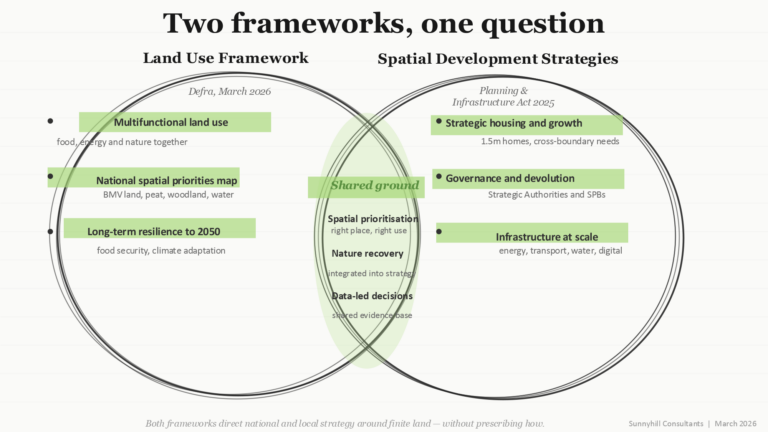
Last week saw the publication of England’s first Land Use Framework, released by Defra on 18 March. It arrives just as Spatial Development Strategies take shape under the Planning and Infrastructure Act 2025. These are first impressions rather than full analysis – but taken together, these two policy instruments mark a significant shift in how England will think about land for decades to come. They come from different departments, speak different languages, and may be aimed at different audiences. Making them work together is going to take some energy and thoughtfulness. We’ve sketched a Venn diagram, beginning to understand both and the overlap!
What the Land Use Framework says
The LUF is England’s first attempt at a coherent national strategy for managing competing demands on a finite resource. Build more homes, generate clean energy, maintain food production, all while restoring nature. The framework’s answer is multifunctionality: the same land delivering several outcomes at once. Central to this is a new national spatial priorities map, showing where the best land for farming, nature recovery, energy and development sits across England. Best and Most Versatile agricultural land is explicitly steered away from renewable energy, habitat restoration or urban expansion, though the framework stops short of preventing it. It will not mandate how any organisation uses its land – it sets out a vision for what England could look like in the 2030s and 2050s if strategic priorities are balanced.
What Spatial Development Strategies require
SDSs are a different kind of instrument. Where the LUF offers a vision and a toolkit, an SDS is a statutory plan with real teeth. Combined authorities, combined county authorities and upper-tier councils are required to produce them under the Planning and Infrastructure Act 2025, addressing housing, infrastructure and environment at a scale that crosses local authority boundaries, over a 30-year horizon. Nature and environment must be integrated into spatial strategy rather than treated as constraints. That is a significant ask of authorities many of whom are starting with limited capacity and no established governance structures.
Where the two connect — and what is missing
The overlap is substantial. Both rest on the same foundational argument: the right development in the right place, enabled by good spatial data. The LUF’s national priorities map and the SDS evidence base are different expressions of the same logic. An authority producing an SDS without a clear picture of BMV land, flood risk, nature recovery corridors, renewable energy potential and food strategies will be making decisions in the dark.
The practical problem is that the two are not yet joined up. The LUF is Defra’s; SDSs are MHCLG’s. The Land Use Unit promised to produce the national priorities map does not yet exist. Strategic authorities are being asked to produce SDSs now, with the LUF evidence base still taking shape. What is also missing is the connective tissue — the engagement processes, evidence frameworks and governance structures that translate two national instruments into coherent regional strategies.
There is also a piece of infrastructure missing entirely: water.
I’ve looked and it doesn’t seem that either treats water supply with the seriousness the evidence demands. The LUF acknowledges water primarily as a co-benefit — better water quality from woodland, reduced flood risk from natural flood management. The SDS regime requires authorities to identify strategic infrastructure requirements, which will, of course, go beyond their geographies. This matters because the gap between supply and demand is already biting in water-scarce areas such as parts of the South East, East of England and the Thames Valley, precisely the geographies where housing pressure is most intense. An SDS produced without a clear understanding of the regional supply-demand picture, water company investment plans and the relationship between land use change and catchment hydrology will be making growth decisions on incomplete foundations. Water is not simply a co-benefit; it’s a vital infrastructure, and it needs to be in the room from the start of any strategic conversation about where communities can genuinely thrive.
What the frameworks don’t reach
Both are built primarily on what can be modelled, measured and mapped — and that is genuinely valuable. But there is a category of knowledge that does not appear in spatial datasets, and neither framework has a serious mechanism for reaching it. Practitioners who have worked in specific geographies for years understand why a particular river valley functions as it does ecologically and economically, why a market town has absorbed or resisted growth, and why a farming or horticultural community is struggling to survive. That kind of understanding cannot be extracted from a consultant’s evidence base assembled in six months. It has to be sought out, and, in our experience, it is rarely sought out early enough.
We have been having some of those conversations, and they are already more textured and more complicated than either document suggests. What people know, what they worry about, and the trade-offs when it’s simply not possible to have everything going on a piece of land at the same time. The frameworks are the beginning of the conversation, but there is significant work to come.